 |
| Project map (via LXRA) |
Just before the 2018 election, the Andrews government announced that if re-elected they would remove three level crossings in Deer Park, as part of their second tranche of 25 level crossings. Somewhat unusually, the Level Crossing Removal Authority (LXRA) announced the preferred method of removal for all three almost immediately. These crossings are all on the section of track shared between the Ballarat and Geelong lines, and I also used to live in Deer Park right near them, so I'm keen to make sure they're done right – and the City of Brimbank is doing early consultation on the project, so now seems like the right time.
I'll get the uncontroversial ones out of the way first, then get stuck into the one I think needs to be changed.
Fitzgerald Road
 |
| The Fitzgerald Road crossing (via City of Brimbank) |
To my mind, Fitzgerald Road was always going to be the most difficult one - it's got the intersection with Tilburn Road/Forrest Street right next to the level crossing, right at the point where the Ring Road goes overhead. Both of these have the potential to really constrain what can be done at the site, so I'd thought dropping the rail line into a trench would be the only option - but the LXRA's preferred option is to leave the track at the existing ground level, and raise the road over the line.
I'm quite surprised by this, but not especially bothered. Going road-over can have negative impacts on walkability and other aspects of the urban form, but here I don't think it'll make much difference; it's already surrounded by the freeway, industrial areas, and large reserves, all of which make it very unwalkable anyway. So if they say it's going to be easier for them, well and good.
Mount Derrimut Road/Station Street
 |
| The existing Deer Park Station |
Mount Derrimut Road/Station Street is right next to Deer Park Station (the reason for the double-barrelled name is that the railway line is the border where the road's name changes). The LXRA's preferred option is to elevate the line and give Deer Park a new elevated station. I agree this is the best option - it's very suitable for the local topography, and presents the best chance of improving local access issues.
Deer Park has a big issue with access from the southwest - the direction I was coming from when I lived there. Because only 3 corners have entrances, if you're coming from the southwest you have to walk all the way past the station to the road, then walk all the way back up the ramp to the platform. This takes several minutes - often, enough to make the difference between catching your train and missing it.
 |
| Diagram of the walkability issues with the existing station (click to embiggen) |
A brand new elevated station presents an opportunity to ensure that everyone can access the station easily, from all directions, without the need to backtrack - and of course without the need to cross the tracks at grade.
 |
| The long ramp from Station St to the platform. Note the bus stops in the distance on Tilburn Rd |
One key requirement will be the need to maintain pedestrian crossings in the area - hopefully with more responsive signals than exist today. The major bus stops for interchange with local routes are on Tilburn Road (and unfortunately would be hard to shift closer to the station) so it'll be important to ensure transferring passengers can do so quickly and safely.
Robinsons Road
 |
| The Robinsons Road crossing during RRL construction in 2013 |
The Robinsons Road crossing, however, does bother me quite a lot. The LXRA's preferred method is to go road-under, which would miss a great opportunity to fix another big problem - killing two birds with one stone, for relatively little extra cost.
Just west of Robinsons Road, the Geelong line splits away from the Ballarat line in a flat junction. This means that a train coming from Geelong must cross over the Ballarat tracks at this point; so a train heading to Ballarat would need to wait for the Geelong train to pass before it could go ahead (or vice versa). This is one of several flat junctions that V/Line trains need to deal with in suburban Melbourne, and together they're a big contributor to the issues we see with capacity and reliability.
 |
| Just west of Robinsons Rd is a flat junction where Geelong trains conflict with Ballarat trains (via Google Maps) |
What should be installed here - what should have been installed here as part of Regional Rail Link - is a flyover. They actually did build one where the RRL tracks join up to the original Geelong line at Manor, near Werribee, but for whatever reason they didn't build one here. This is a long-standing issue, and the removal of the level crossing is a golden opportunity - because in layman's terms, a flyover is basically a big rail bridge.
 |
| The Manor flyover, with the old Geelong line merging with RRL tracks (via RRL Authority, I think) |
 |
| Diagram of this junction. Note that North is at the bottom left of the image. (source unknown) |
If the LXRA went rail-over Robinsons Road, they could make it into a flyover as well - just by dropping the Ballarat line back to the surface a bit earlier than they drop the Geelong line. Simples!
 |
| Potential flyover design at Robinsons Road |
Open, walkable space
Now, if Mount Derrimit Road/Station Street is going to be rail-over, and Robinsons Road would also be rail-over, would they just leave the track elevated in between, or drop it down to ground level?
They kept the track elevated for 1km between Murrumbeena Road and Poath Road, but dropped it for the 1.4km between Heatherton Road and Chandler Road; the gap in Deer Park is 1.65km, so they probably won't be inclined to keep it up. However, I'd argue that they should.
 |
| A pedestrian crossing halfway along the corridor would dramatically improve access (via Google Maps) |
Currently, the rail corridor splits Deer Park in two. The two roads, 1.65km apart, are currently the only places you can cross the rail line - there are zero pedestrian crossings in between. This makes it impractical for people living just south of the railway line to walk to the sporting facilities and schools just north of the railway line. And because of the way the state school zones work, people south of the line have to send their kids to Deer Park West Primary, north of the line - it's closer as the crow flies than Derrimut Primary, but they have to take a long, roundabout trip to actually get there.
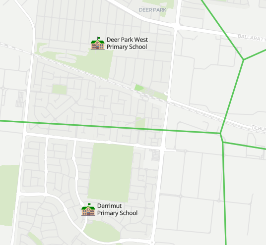 |
| Many students in Deer Park West's catchment are cut off by the railway line (via Find My School) |
If you elevate the railway line through here, you can give people access to this public space - not only could they walk across the corridor freely, you can create gardens or sports facilities or whatever else you want along it. Just look at the great open space that was created between Caulfield and Dandenong! This creation of new open space is the great success story of Skyrail, and suburbs in Melbourne's west deserve this just as much as those in the east.
 |
| The Djerring trail under the Caulfield-Dandenong Skyrail (via LXRA) |
These three crossings probably won't be removed for a few years - and they may well be done concurrently with electrification and/or quadding - but if we want the best result for the people of Deer Park, we need to start advocating now.
No comments:
Post a Comment