 |
| Illustrative concept plan for reopening Bridge Mall (via City of Ballarat) |
Design firm Hassell has put forward detailed designs for reopening Bridge Mall and redesigning Grenville Street, which will be considered by Ballarat Council this Wednesday. So what's in store?
Shortly after my last post on the subject, Council approved the high-level decision for car traffic to go one-way eastbound, allowing Hassell to flesh out their designs more - and what we see in next week's meeting agenda does broadly match what we saw last time, just with more detail. Unfortunately, on several issues where I previously said "This is worth keeping an eye on, but I feel okay for now", the details aren't what I was hoping for.
 |
| Proposed allocation of space on Grenville St (via City of Ballarat) |
Grenville Street still has a footpath adjacent to the wall of the pharmacy, then a bunch of green space, then a shared-use path, then a green buffer before the road. Though the dimensions weren't specified last time, compared to the sketches and renders it seems that the footpath has narrowed significantly, while the main bit of green space has widened significantly - the footpath is 3m wide, while the green space is ~7.2m, the shared-use path 2.75m, and the green buffer 3m.
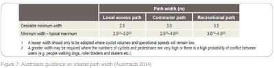 |
| Austroads guidance on shared path widths (via Victoria Walks) |
Given that this is going to be an incredibly high-pedestrian area, and will form an incredibly important link in the city's strategic cycling network, a 2.75m shared-use path is not sufficient for cyclists. The diagram says "Shared path reduced to 2.75m as per Ausroads standards (Recommended recreational and regional commuter paths)" but the Austroads standards actually indicate a minimum of 3.0m for a regional/commuter path and 3.5m for a recreational path. It's also worth noting that in situations where high flows of pedestrians or cyclists (or both) are anticipated, Austroads recommends you don't use a shared path at all, you should have separated foot and cycle paths - 2.5m for cyclists and 2.0m for pedestrians for a total of 4.5m (p35).
 |
| Where cycle demand is high, and there's an alt footpath, it should be a bike path (via Victoria Walks) |
On Grenville St, we can expect high flows of pedestrians and of cyclists, and there is a dedicated 3.0m footpath adjacent for the pedestrians to use - so the shared-use path must either be allocated solely for cyclists, or widened to 3.0m, or both. Any widening should be easily achievable by removing a negligible amount of the green space.
 |
| Proposed cycle routes through the precinct (via City of Ballarat) |
When it comes to the Mall itself, unfortunately the picture is no rosier. Given that the Mall area is where several strategic routes in the Cycling Action Plan intersect, they've done a whole diagram showing where each route goes. You have to look quite closely at the diagram to tell, but along Bridge Street itself, cyclists will mainly need to "take the lane" with cars to travel eastbound, and there is no provision for contraflow cycling for those headed west. They're indicating that the footpaths directly in front of the shopfronts will be shared between cyclists and pedestrians, which again is totally inappropriate in this context - there will be tons of pedestrians and cafe tables and clothes racks and people emerging suddenly from shop entrances, which is no place for a cyclist to coexist. To be clear I don't think cyclists should be banned from these areas, it's just that it's only appropriate for very slow and cautious cycling - for the last few metres while searching for a bike park, for example, or riding alongside a friend who's walking. It should be supplementary to the through-route, not instead of it.
Westbound cyclist who want to proceed at a normal pace could use what's labelled as an "Upgraded cycle route" along Little Bridge Street - but there are no detailed cross-sections for this road yet, and from the overhead map there is no indication there'd be any separation. It looks like cyclists would again be expected to take the lane, but this time on a road with much higher traffic volumes, probably higher speeds, and the need to look out for both parked cars reversing to the right and emerging buses to the left - unacceptably unsafe for such a key cycling route.
 |
| Pieter Cornelisz Hooftstraat in Amsterdam is one-way for cars and two-way for bikes |
If the return of cars to Bridge Mall goes how its proponents intend it to - and I'm wary but hopeful about this - there will only be a small volume of cars, travelling slowly and cautiously. In that kind of environment, two-way cycling can safely coexist with one-way motor traffic, as it does in many autoluw - "low-car" shopping streets - in the Netherlands. Bikes travelling in the same direction as cars "take the lane", with confidence that the few cars will drive slowly, while a narrower bike-only lane is provided for cycling in the opposite direction. That's the model we should be going for here, and again should be achievable in the space we have available - but given the proposed layout (ie lots of angle parking to the right of the through-lane) would probably require a substantial rethink of precisely where each bit goes.
 |
| Bridge Street Material Expression (via City of Ballarat) |
For what it's worth, when it comes to the aesthetics and many other aspects of what's planned, I think Hassell have done a brilliant job. I love their thinking on reconnecting to the water of the Yarrowee, I love the Coliseum Walk arbour idea, I love the materials they're proposing to use - it seems like it will feel like a really great place once it's finished.
They just haven't given cycling quite the prominence it deserves and requires - if we can make these tweaks to give cyclists the safe space they need, the final product should be fantastic.
No comments:
Post a Comment